
Urban planning in the 21st century: challenges and solutions
Urban planning is not a new concept, but today it is at the center of societal debates more than ever before. Why? Because cities are not only growing, they are also changing rapidly. More and more people are moving to urban areas, resources are becoming scarcer, climate change is knocking at the door – and at the same time, quality of life is expected to increase. Urban planning is therefore much more than road construction and zoning plans – it is a multidisciplinary process that significantly shapes our future. In this article, we take a look at the challenges urban planners face today – and what smart, sustainable solutions can look like.
What does urban planning mean today?
The shift from functional to sustainable cities
In the past, urban planning primarily focused on functionality: where to build, how to get from A to B as quickly as possible, where the next power plant should go. But this one-dimensional view has become outdated. Today, the principle of sustainability is at the forefront. Cities should not only function – they should be livable, ecological, socially just, and future-proof. That means: fewer concrete jungles, more green spaces; less car traffic, more quality of life; less social division, more inclusion.
The focus is shifting from purely technical planning to a holistic, integrated approach. Topics such as energy efficiency, resource conservation, social integration, and citizen participation are now standard. It’s about understanding the city as a living space – not just as a collection of buildings and roads.
Goals of modern urban planning
Modern urban planning pursues multiple, interconnected goals. These include:
- Sustainability: Ecological aspects such as CO₂ reduction, energy efficiency, and climate adaptation are key.
- Quality of life: Public spaces, local recreation, cultural offerings, and social diversity contribute to a city's appeal.
- Participation: Citizens should help shape their environment – not only through elections but also through concrete projects.
- Resilience: Cities must be prepared for crises such as pandemics or extreme weather events.
- Innovation: Digitalisation and smart technologies open up new possibilities for planning and administration.
Overall, the goal is to design cities in such a way that they can meet the challenges of the present and future – while remaining places where people enjoy living.
Urban Transformation and Changing Approaches to Planning
A new kind of digital urban planning is revolutionising the planning process and the way we design urban environments. Instead of developing individual design solutions, at AIT we rely on parametric models combined with artificial intelligence (AI) that can flexibly generate and evaluate a wide range of design iterations. The aim is not only to provide maximum transparency and save time for clients, but also to identify the highest-performing design approaches and set the course for the project correctly from the outset.
The integration of complex simulations and AI allows us to incorporate topics such as mobility, energy, climate, and more into the planning process – from the urban scale (GIS) right down to the building level – enabling the development of optimised designs. This transforms rough assumptions from traditional design processes into informed and evaluated designs that can be discussed on a factual basis, for example in the City Intelligence Lab (CIL), our platform for sustainable urban development. We support cities, property developers, and planning offices in digitalising planning processes and in holistically assessing planning steps to enable evidence-based decision-making.
City Intelligence Lab at AIT
Resilient Urban Planning: Data-Driven and Participatory
Sustainable urban development projects are based on the principle of resilience, which aims to make cities more resistant to climatic extremes and their impacts. In this context, creative solutions are developed to enhance both the adaptability and resilience of urban systems and infrastructures.
Evidence-based decision-making plays a crucial role in this process, relying on scientifically grounded data and insights to maximise the effectiveness of measures. Furthermore, interactive co-creation and stakeholder engagement promote a participatory approach, in which various interest groups are actively involved in the planning process. This makes it possible to integrate diverse perspectives and areas of expertise and to jointly develop viable solutions that reflect the needs and priorities of the community.
AIT enables a holistic perspective and can provide cross-domain support – thereby reducing interface complexity and facilitating effective development.
Holistic approach to digital urban planning – from GIS to BIM and interactive city models
AIT solutions for digital urban planning
We support cities, decision-makers, and planners in the development of strategies, digital tool-based planning processes, and the integration of different domains at interfaces for a holistic perspective. A selection of our services is listed below, although we always strive to develop the optimal solution for our clients and are happy to address individual challenges:
Sustainable project and district development
- Process support for urban planning processes (masterplans for sustainable urban planning and development)
- Support for urban design competitions
- Site assessment – potentials and risks
Solutions for sustainable cities
- GIS-based land use planning
- Quality assurance in development / land-use planning
- Living labs and planning support
Innovative and optimised planning processes
Sustainable project and district development
Process Support for Urban Planning Processes (Masterplans for Sustainable Urban Planning and Development)
Support in the development of masterplans for sustainable urban planning begins with the assessment of the initial situation and framework conditions of the project area, in order to create a sound basis for the planning process. A dynamic and cooperative masterplanning process is designed to enable flexible responses to changes and new insights. Ongoing quality assurance across the themes of climate resilience, mobility, and energy ensures that the planning aligns with defined objectives and delivers sustainable solutions.
A central communication platform for digital planning models – from GIS to BIM – facilitates the exchange of information and collaboration among stakeholders. Stakeholder engagement is ensured through co-creation workshops, surveys, and transparent processes, making sure that a variety of perspectives and needs are taken into account.
By establishing evidence-based foundations for decision-making grounded in scientific research, it is ensured that planning is based on robust findings and supports the sustainability of urban development.
The added value of early involvement in the process provides the greatest leverage for change and can support the development of optimal solutions within a dynamic process.
Support for urban planning competitions
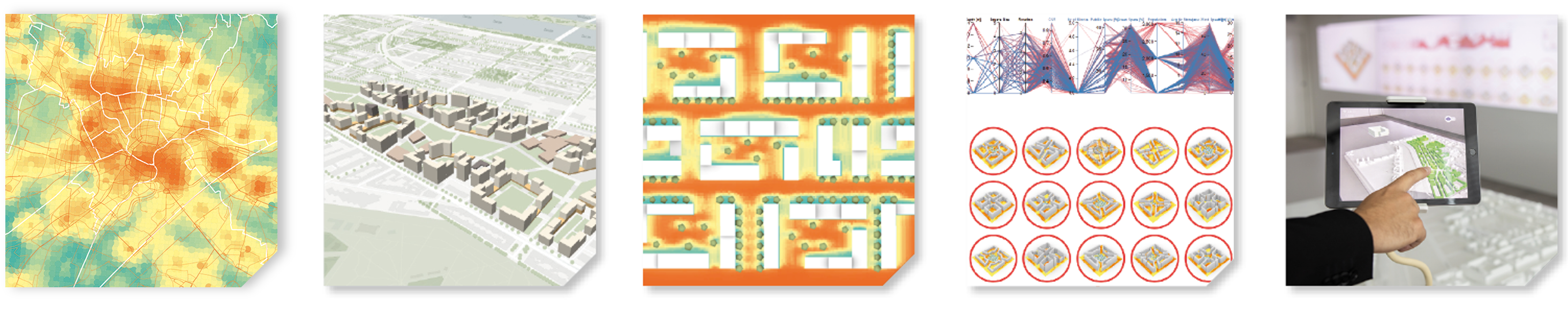
AIT provides support in setting up competition tenders focused on climate resilience, mobility, digital planning, and energy. This is a critical factor for the success of any project. We offer comprehensive support in reviewing framework conditions and target values for their feasibility using semi-automated 3D development scenarios, for example through the creation of digital open space and density scenarios.
We also advise developers on the necessary level of detail required in different planning phases to enable reliable simulations. Another key area of focus is the definition and evaluation of framework conditions and target values for districts, ensuring sustainable and efficient implementation. In addition, we support communication and coordination with all stakeholders to create a transparent and collaborative planning foundation. The evaluation of competition entries follows, along with a performance assessment based on a defined KPI set that covers multiple domains.
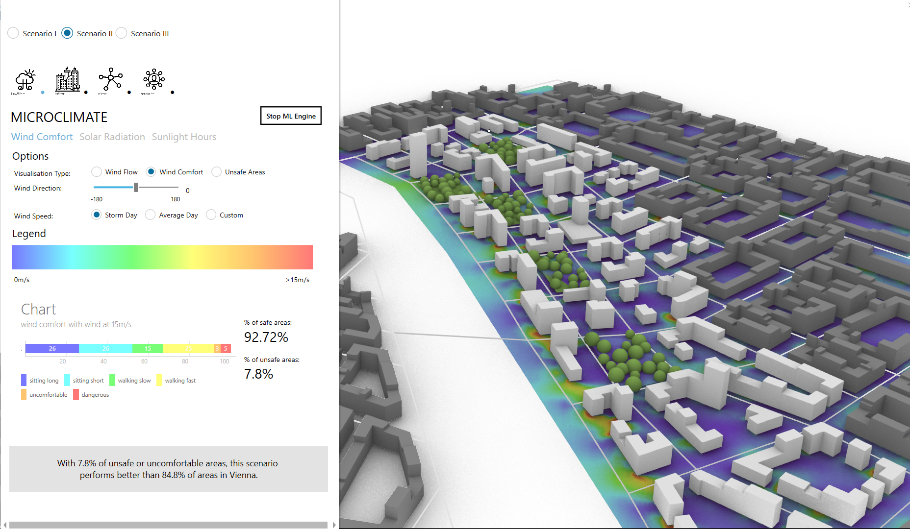
Urban climate simulations are also conducted for selected weather events, such as heatwaves, in order to assess their impact on development scenarios. High-resolution microclimate simulations for building block scenarios are used to identify optimisation potential. Finally, a detailed analysis of the mobility-related impacts on the surrounding area is carried out to ensure a holistic evaluation and align the planning process with a sustainable and more resilient future.
Parametric digital planning model including real-time evaluation
site assessment - potentials and risks
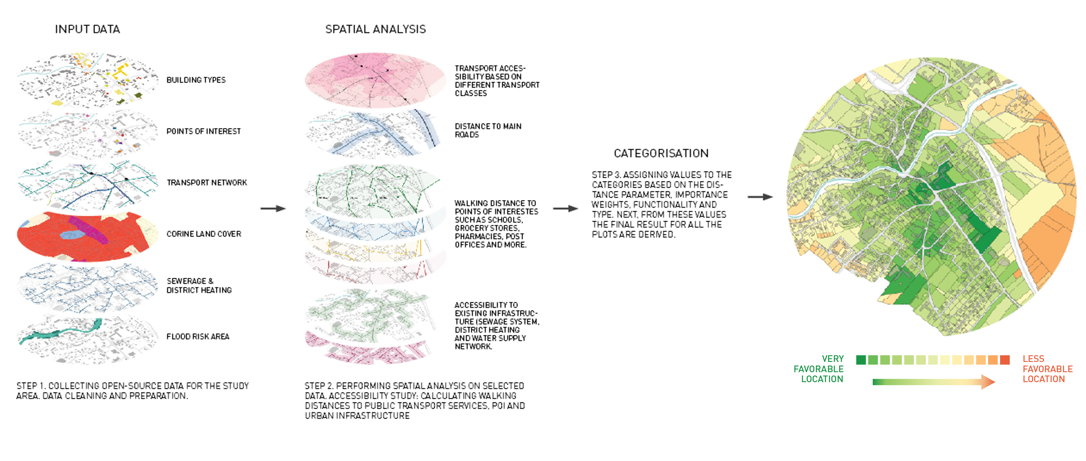
Site assessment is a key component in the planning and development of urban areas and is supported by a wide range of geodata analyses. Through the collection, preparation, and structuring of data, extensive databases are created that serve as the foundation for analysis. Various evaluations are carried out, linking demographic and spatial data—for example, the availability of green space and cluster analyses. Potential analyses compare the current status quo with different development scenarios, taking into account factors such as the improvement of thermal comfort in both summer and winter, as well as the analysis of energy potential, for instance through photovoltaics. Additionally, accessibility of the sites is assessed for different modes of transport including public transport, individual vehicles, and pedestrians, in order to evaluate connectivity. The attractiveness potential for individual sharing systems is also examined to promote innovative mobility solutions and enhance quality of life in urban areas. A comprehensive site assessment enables well-informed decisions that support sustainable development and improve the quality of life in urban environments.
Solutions for sustainable cities
Evidence-Based Land Use Planning (GIS)
GIS-based land use planning is an effective tool for implementing targeted measures to mobilise building land and activate vacant spaces in order to promote inner-city development, while also preventing and reducing erosion and vacancy. Through comprehensive needs assessments—such as workshops with relevant stakeholders—specific requirements and challenges can be identified. GIS analyses then allow for the spatial delineation of potential areas for inner development.
The prioritisation of these areas is carried out based on clearly defined objectives established in dialogue with stakeholders. By engaging stakeholders and fostering dialogue, broad support for the proposed measures is achieved. Development perspectives and options are elaborated through scenario development to ensure future-oriented and sustainable land use. In this way, GIS-based land use and development planning can help guide urban development in a targeted manner and effect positive change in the urban landscape.
Our methodology:
- Needs assessment workshop with stakeholders
- Spatial delineation (GIS analyses)
- Prioritisation (goal definition)
- Initiating dialogue (stakeholder engagement)
- Development perspectives & options (scenario development)
GIS-based classification of real estate – comprehensive evaluation
Quality assurance of development plan / urban land-use planning
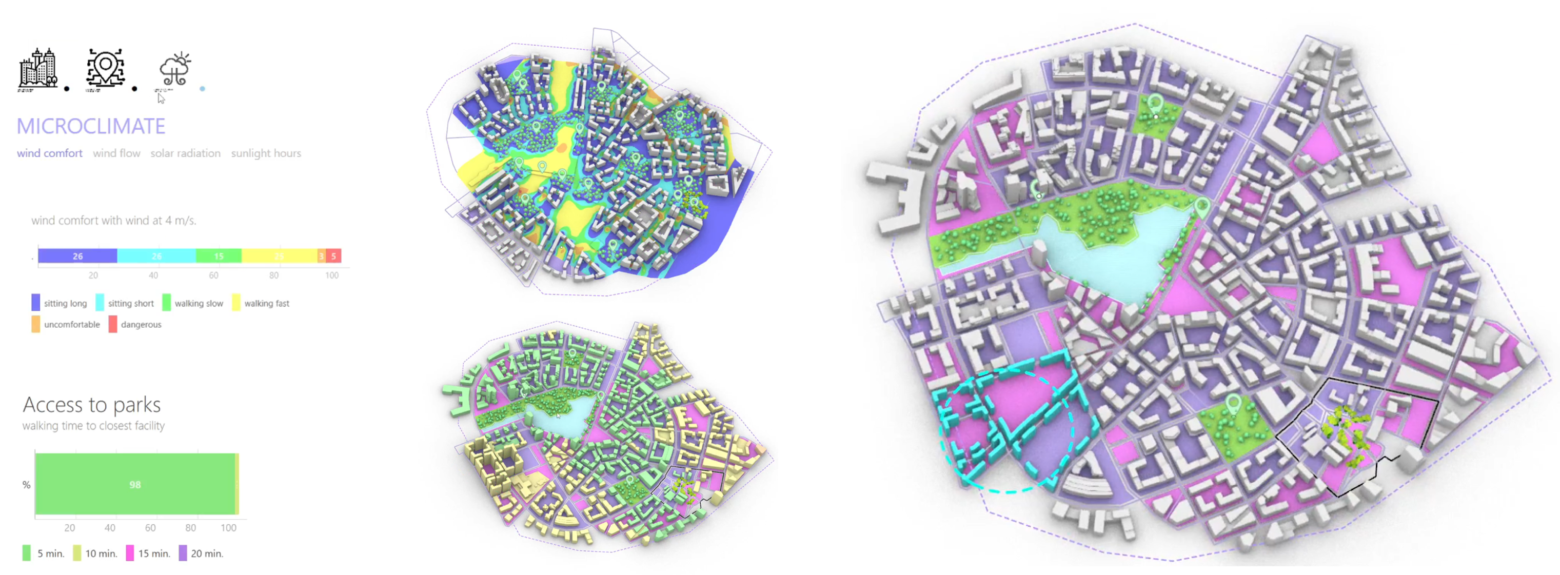
Quality assurance in development and land-use planning includes a cross-domain performance evaluation of various planning scenarios to ensure that the goals and requirements of the planning process are met. This involves consideration of different planning KPIs, including the ratio of floor area index (FAI), gross floor area (GFA), and density per plot, as well as the proportion of green space.
In terms of climate resilience, factors such as water management (including runoff coefficients and retention potential), microclimate, wind comfort, and hours of sunlight on key reference dates in open spaces and on building façades are analysed.
Mobility is assessed through walkability analyses, such as pedestrian accessibility to points of interest (PoIs), along with estimates of traffic volumes.
In the field of energy, an integrated demand analysis is carried out, along with an assessment of the potential for photovoltaics (PV) and various decarbonisation scenarios. This comprehensive performance evaluation enables planning variants to be assessed and optimised holistically, ensuring sustainable and future-proof development.
Living Labs and Planning Support
In the context of sustainable urban planning, living labs and planning support play a crucial role in implementing participation and promoting stakeholder engagement. With a focus on participation that ranges from information provision and consultation to cooperative processes, stakeholders are actively integrated into the planning process.
Effective awareness-raising is supported through the use of virtual and augmented reality in collaboration with stakeholders, enabling complex planning content to be communicated in an engaging and accessible way and developed collaboratively. Planning support is tailored to specific target groups in order to address the distinct needs and interests of those involved, and to promote sustainable development that benefits all stakeholders.
Living labs and planning support
Innovative and optimised planning processes
Digital Workflow Development and Optimisation of Planning Processes
Digital workflow design and optimisation is a key step towards increasing efficiency and ensuring quality in planning and development processes. This process begins with a clear definition of objectives and boundary conditions to establish the framework for workflow design. A thorough review of existing workflows enables the identification of strengths, weaknesses, opportunities, and threats (SWOT analysis).
Based on these insights, a customised process design is developed, tailored to the specific requirements and needs of the project. Capacity-building training equips staff to implement and utilise the new processes effectively. In addition, scripts for co-creation and parametric planning are developed to foster collaborative working methods and automate complex planning tasks.
The integration of interfaces with the AIT simulation suite allows planning to be supported with simulation-based analyses, enabling well-informed decision-making. Overall, digital workflow design and optimisation contributes to improving efficiency, accuracy, and innovation in planning processes, ultimately enhancing the quality of outcomes.
Interactive urban planning model with user interface
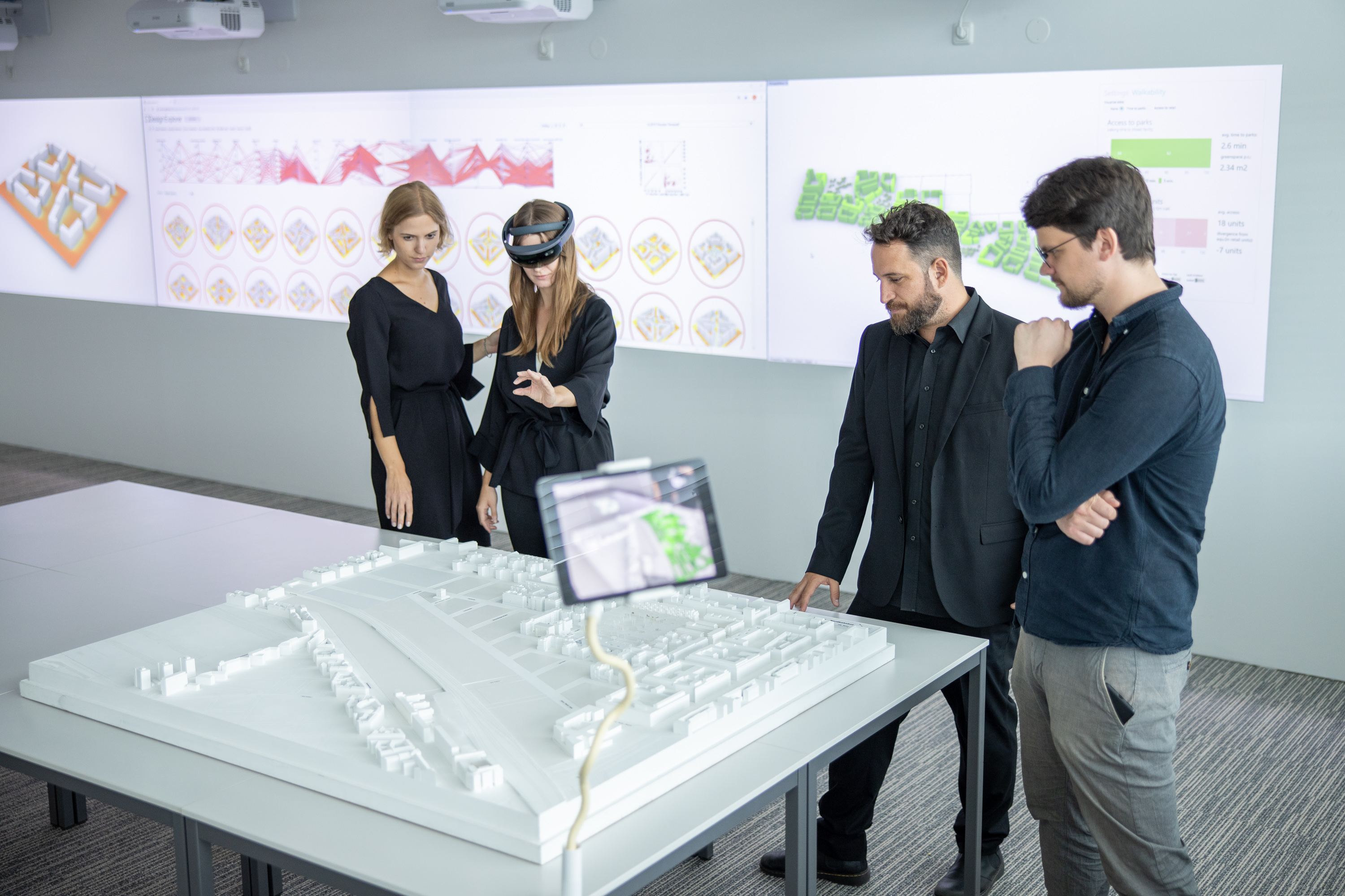
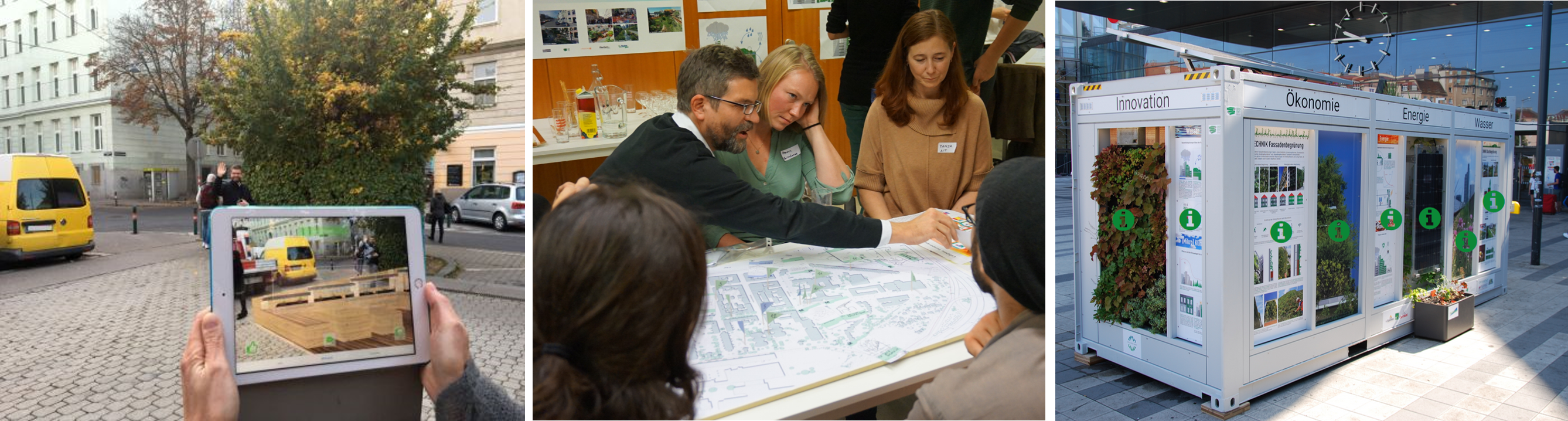
Interactive co-creation with stakeholders
Interactive co-creation is an effective approach for involving stakeholders in urban planning processes, based on augmented reality (AR) and interactive planning models. Through interactive workshops involving stakeholders such as project partners, citizens, and political representatives, evidence-based decision-making is promoted.
These workshops provide opportunities to collaboratively develop solutions and exchange ideas, leading to broader acceptance and a deeper understanding of planning decisions. Performance is evaluated based on selected KPIs, which enable the monitoring of progress and the effectiveness of proposed measures. By utilising co-creation within interactive planning models, urban planners can enhance stakeholder engagement, increase transparency, and ultimately create more inclusive and sustainable urban environments.
