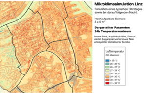
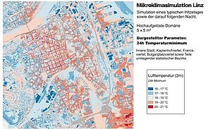
The "Climate Neutrality Concept" is setting the stage for Linz to become a climate-neutral industrial city by 2040. As part of these efforts, the Linz City Council tasked the Department of Urban Climatology and Environment in 2021 with establishing a meteorological monitoring network. This initiative aims to enhance the city's climate data and allow for more comprehensive monitoring of climate indicators, such as heatwave days and tropical nights.
The AIT Austrian Institute of Technology conducted the scientific study and simulations, which resulted in an unprecedentedly detailed dataset. This valuable information can aid urban development, climate adaptation strategies, and improve the quality of life for Linz residents. Building on these results, establishing a microclimatic monitoring network is critical for better understanding heat exposure in Linz, implementing targeted climate adaptation measures, and continuing to refine microclimate simulations.
Scientific Study and AIT Simulations Provide Unique Insights
“The detailed simulations depict the city’s microclimate with a resolution of up to 5 x 5 meters, allowing us to precisely analyze how factors like construction, green spaces, and other elements impact temperature and air circulation across different city districts,” says Dr. Johannes Horak, head of Linz's Department of Urban Climatology and Environment.
Another key aspect of the project is identifying optimal locations for an urban microclimate monitoring network. By combining the simulation results with detailed urban structure data, 50 potential sites for meteorological stations were selected, ensuring comprehensive long-term climate monitoring for the city.
“The high-resolution simulations provide us with valuable insights to better understand complex urban climate phenomena and develop targeted adaptation strategies,” explains Dr. Marianne Bügelmayer-Blaschek, climate impact research expert and project lead at AIT.
Advanced Method Enables Precise Climate Simulations and Microclimate Modeling
Simulations conducted with PALM-4U (Parallelized Large-Eddy-Simulation Model for Urban Applications) generated a wealth of data that surpasses previous information on the city’s microclimate. Analysis of maximum air temperatures at 2 meters above ground shows significantly higher temperatures in sealed areas such as streets and bridges. The high resolution of up to 5 meters also highlights the cooling effects of green courtyards and parks in the city center.
The simulations also reveal a noticeable temperature decrease with increasing elevation, reduced construction density, and more green spaces. Striking differences between street-level and rooftop temperatures were observed: while rooftops experience large temperature fluctuations, streets without greenery remain at high temperature levels during summer heatwaves. These sample findings represent only a small fraction of possible analyses.
An additional important factor for summer comfort in the city is the cold air flow. Various parameters were analyzed, with PALM-4U using the volumetric flow rate as a key indicator. This parameter shows the volume of air passing through an imaginary 1-meter-wide, 50-meter-high "gate" per second. The simulations indicate that cold air from the northern unbuilt slopes flows into the city via valleys such as Haselgraben and Dießenleitengraben, or along streets like Altenbergerstraße, and from Außer- and Mittertreffling. With northwesterly winds, cool air is also transported across the Danube to the city center. In the southern districts of Ebelsberg, Neue Heimat, Kleinmünchen, and Bindermichel-Keferfeld, the loose construction and numerous green spaces enhance the cold air flow.
Due to its highly urbanized structure and population density, the inner districts of Linz, such as Franckviertel, Bulgariplatz, and parts of Kaplanhof, were simulated with an even higher resolution of 5 x 5 meters. These high-resolution simulations could also serve as the foundation for a microclimate monitoring initiative under the pioneering city project "Linz with Ambitio3xn."
Selection of Sites for the Monitoring Network
The selection of optimal sites for the microclimate monitoring network followed a multi-stage process. Initially, Local Climate Zones (LCZ) were established to objectively characterize Linz's urban areas based on construction criteria. This classification makes it possible to identify different urban structures and their specific climate characteristics. In parallel, a representative summer day was simulated using the advanced PALM-4U model, which provided high-resolution data for Linz (spatial resolutions of 5 x 5 meters and 10 x 10 meters), allowing for a detailed analysis of the city's microclimate.
Based on defined site criteria, the simulation results were combined with LCZ data to identify areas particularly suitable for climate monitoring. These locations were then matched with potential sites, such as concrete poles or municipal buildings. Discussions with equipment manufacturers were also held to recommend appropriate measuring devices and optimize the technical requirements for the monitoring network.
Establishment of a Microclimatic Monitoring Network
These detailed findings directly contributed to selecting locations for the monitoring network. A total of 50 potential sites were identified, enabling precise monitoring of Linz's urban microclimate. The underlying datasets are available to the city of Linz, and the developed methodology has been documented in a final report. This ensures that Linz can independently identify additional locations in the future and flexibly expand the monitoring network. Establishing a microclimatic monitoring network is crucial for better understanding heat stress in Linz, implementing targeted climate adaptation measures, and further evaluating microclimate simulations.
Project Report and Press Images
The project report, result maps, and additional information are available for download here.


